
Floodplain Development
The Federal Emergency Management Administration (FEMA) defines a floodplain as any land area susceptible to being inundated by floodwaters from any source. This can include coastal areas impacted by storm surge, land along a river or bayou that is flooded when that waterway rises out of its banks, or low-lying land that fills with water when it rains. Flooding occurs in a wide range of landscapes due to rainfall or storm surge.
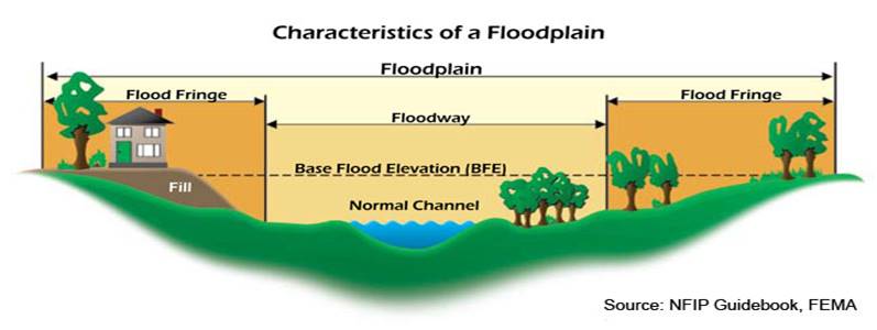
- Floodway is “the channel of a river or other water course and the adjacent land areas that must be reserved in order to discharge the base flood without cumulatively increasing the water surface elevation more than a designated height.” In a flood event, the floodway functions as part of the waterway, and is filled with flowing water.
- 1 percent (100-year) floodplain is land that is covered in water during a flood event that has a 1 percent chance of being equaled or exceeded each year.
- 0.2 percent (500-year) floodplain is land that is covered in water during a flood event that has a 0.2 percent chance of being equaled or exceeded each year.
- Base Flood Elevation (BFE) is the elevation of surface water resulting from a flood that has a 1% chance of equaling or exceeding that level in any given year.
Floods are one of the most common hazards in the United States. Flood effects can be local, impacting a neighborhood or community, or very large, affecting entire river basins and multiple states. It is important to be aware of flood hazards no matter where you live. Even very small streams, gullies, creeks, culverts, dry streambeds, or low-lying ground that appears harmless in dry weather can flood.
Floodplain maps and information on flood insurance coverage and requirements, flood protection measures, flood safety, and property and building protection are available at the Guadalupe County Environmental Health Department. Property owners can take actions in advance of a flood to provide protection for their property. Floodplain maps and helpful FEMA publications are also located in the Seguin, Marion and Schertz libraries.
Development within the Regulatory Floodplain is monitored by the Guadalupe County Floodplain Administrator through the enforcement of the Guadalupe County Flood Damage Prevention Order. The main component of this regulation is the issuance of Floodplain Development Permits. Development is defined as any man-made change to improved and unimproved real estate, including but not limited to buildings or other structures, mining, dredging, filling, grading, paving, excavation or drilling operations or storage of equipment or materials.
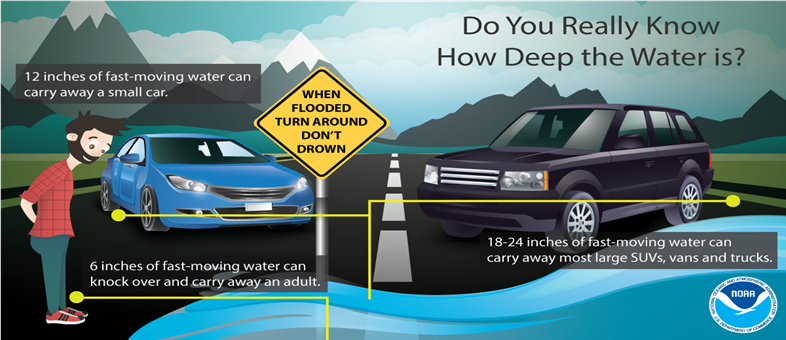
Reminder: Turn around, don’t drown. If you see water on the road, be safe and take a different route.
Forms:
Floodplain Development Application Packet (pdf)
Base Flood Elevation Certificate (pdf download)
Residential Floodproofing Certificate (pdf)
Non-Residential Floodproofing Certificate (pdf)
Resources:
Guadalupe County Flood Damage Prevention Order (pdf)
Frequently Asked Questions about Floodplain
Floodplain Development Permit Process
Flood Insurance Rate Maps (FIRM)
Flood Insurance Study (FIS)
- Flood Insurance Study - Volume 1 of 3 (pdf)
- Flood Insurance Study - Volume 2 of 3 (pdf)
- Flood Insurance Study - Volume 3 of 3 (pdf)
- Elevation Certificate by Address (pdf)
NOAA Atlas 14 Point Precipitation Frequency
Floodplain Management Quick Guide
Regulations for Floodplain Development (pdf)
No-Rise Certificate Requirements for Floodways
Grading, Filling, Channel Improvements, and Excavations in the Floodways (pdf)
Recreational Vehicles Requirements located in the Floodplain
Floodplain Stop Work Order Flow Chart (pdf)
Floodplain Development Brochure (pdf)
Substantial Improvement or Substantial Damage- Notice to Property Owner (pdf)
Improvement Costs - Notice to Property Owner (pdf)
Canyon Lake Dam Inundation Area (pdf)
Letter of Map Revision Fact Sheet
Protecting Manufactured Homes from floods and other hazards
Protecting Utilities from flood damage
Homeowners Guide to Retrofitting
Build with Flood Damage Resistant Materials
44 CFR 60.3 - Floodplain Management Criteria – Permit Requirement
Texas Water Code 26.014 & 26.173 Power to Enter Property (Water)
If a River Runs Through It, What Law Applies? (Texas Department of Parks and Wildlife)
Educational Websites:
Information about Floods, Risk of Financial Loss, and Flood Insurance
Flood Risk Basics and Communities – a Customer Experience Toolkit Video
Flood Risk Communication Video Series
Getting Ready for Disaster – a Family’s Experience
Being ready for disasters takes preparation. Know your risk, make a plan, build a kit